Satellite Images Show Cyclone Arnab Weakening Over India As New System Brews
· GlobeWire Daily Science Desk · Source: www.indiatoday.in
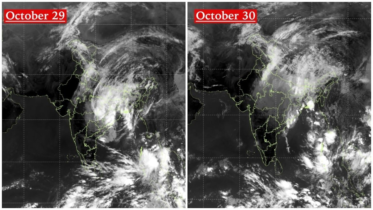
Image: India Today · Photo source · Resized and letterboxed to 16:9; no AI generation
Recent satellite imagery from India's INSAT-3DS satellite documents the northward movement and gradual weakening of Cyclone Arnab across eastern and central India. According to the India Meteorological Department (IMD), the system has transitioned into a well-marked low-pressure area, shifting meteorological focus toward rainfall risks and a developing system over the Andaman Sea.
INSAT-3DS Imagery Analysis
- October 29 Image: Captured a large, organised mass of dense clouds spreading across eastern and central India, with bands extending toward northeastern regions, particularly prominent over Odisha, Chhattisgarh, Jharkhand, and West Bengal.
- October 30 Image: Showed the cloud mass continuing northward with a less organised, more diffuse circulation structure compared to the previous day.
Transition from Severe Storm to Low-Pressure Area
Arnab initially developed into a Very Severe Cyclonic Storm over the Bay of Bengal before moving inland. According to the IMD's assessment issued at 9:15 pm on October 29, the depression weakened into a well-marked low-pressure area at 5:30 pm on October 29 over central Chhattisgarh and adjoining Odisha. The weather agency expects the system to move north-northeastwards and weaken further into a standard low-pressure area over northeast Chhattisgarh and surrounding areas within 24 hours.
Despite the weakening winds, meteorological authorities emphasize that the remnant moisture and circulation continue to pose rainfall and thunderstorm risks across parts of eastern and central India.
New Weather System in the Andaman Sea
In addition to tracking Arnab's remnants, the October 30 satellite data revealed a separate area of intense cloud activity over the South Andaman Sea and adjoining regions. The IMD has identified this as a low-pressure area designated as system A, while tracking Arnab's remnants as system B.
Practical Implications and Verification
- Rainfall Risks: Residents in affected regions should monitor official alerts for potential heavy rainfall and localized thunderstorms.
- Verification: Citizens can check official updates directly through the India Meteorological Department (IMD) website or authenticated meteorological bulletins to verify ongoing weather advisories.
AI-assisted reporting; source claims are attributed and have not been independently verified.
More to read
 IMD Tracks Cyclone Arnab Remnants and New Bay of Bengal System for Weekend Rain Across India
 Cyclone Arnab's Remnants Spread Across India as Satellite Imagery Captures Vast Cloud Shield
 Satellites Capture Cyclone Arnab Approaching India's Eastern Coast
 New Weather System Forms Over Bay of Bengal Following Cyclone Arnab
Trending on GlobeWire Daily
Selected from recent coverage and related topics; not live search rankings.
 Madhya Pradesh Government Plans Revenue Generation from 117-Year-Old Edward Villa in Mumbai Through Leasing
 iPhone 18 Pro Named TechRadar Product of the Year 2026
 Google Project Suncatcher Runs Gemma 4 AI on Orbiting Satellite and Receives First Response
 Gender Disparities in Eye Care Access Across India Examined
 Expanding Green and Blue Spaces Crucial for India's Economic and Public Health, Reports Indicate
 Singapore Layoffs Hit 6-Year High in Q3 2026 With 4,800 Job Cuts