How NASA's PACE Satellite Is Transforming Fall Foliage Tracking from Space
· GlobeWire Daily Science Desk · Source: science.nasa.gov
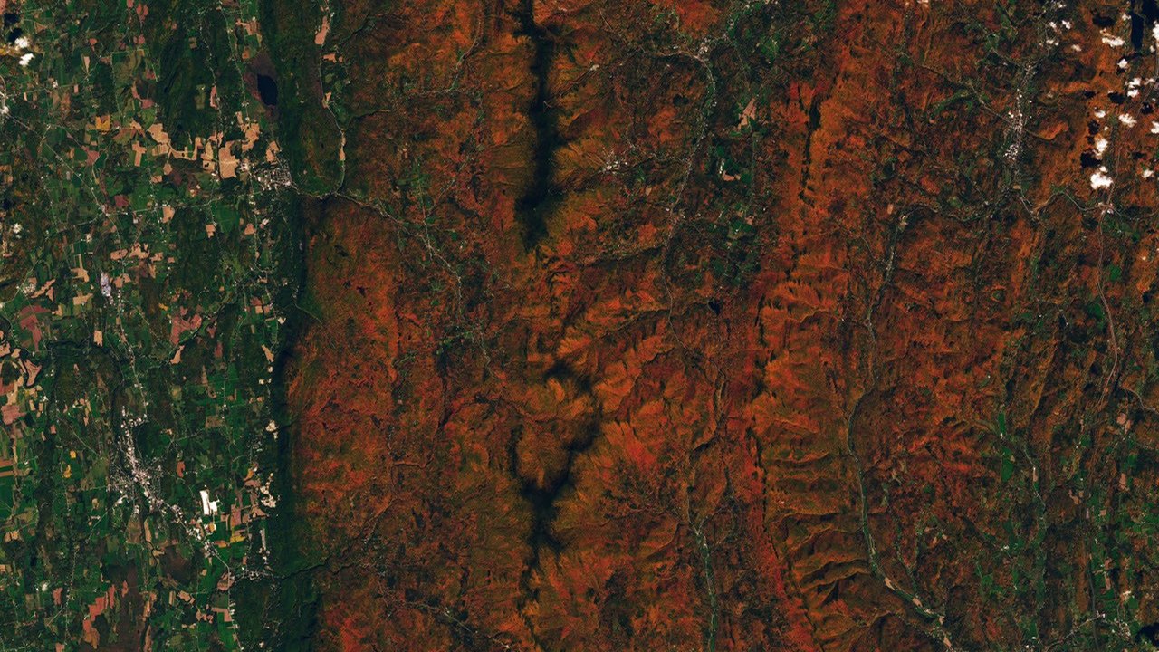
Image: science.nasa.gov — Creative Commons
Tracking Autumn Color from Orbit
A centuries-old tradition is getting a modern update as scientists use advanced satellite technology to monitor autumn leaves on a global scale. While cultural practices like Japan's momijigari ("red leaf hunting") and American leaf-peeping traditions date back generations, researchers now have daily, high-resolution tools to track how forests change color across the planet.
The Ocean Color Instrument (OCI) aboard NASA's Plankton, Aerosol, Cloud, ocean Ecosystem (PACE) satellite observes Earth's oceans and land vegetation daily across 286 spectral bands. Among these are specific wavelengths that enable scientists to measure subtle shifts in leaf pigments responsible for autumn displays: anthocyanins (reds), carotenoids (yellows and oranges), and chlorophylls (greens).
How Satellite Pigment Tracking Works
By measuring the ratio of red, orange, and yellow hues relative to green, scientists can map where leaves are changing and when foliage peaks. According to NASA data, vegetation redness values near 1 indicate balanced red and green levels where leaves remain largely green. Higher values point to increasing concentrations of red pigments.
Data from late September and early October recorded high levels of redness in northern regions, including parts of northern Alaska, Canada, and Russia, where plants like blueberries, bilberries, sedges, and mosses contribute to tundra colors. Meanwhile, historic maple-heavy regions like New York's Adirondacks, Vermont's Green Mountains, and New Hampshire's White Mountains showed vibrant displays driven by sugar and red maples.
NASA researchers note that not all high red or yellow values strictly indicate autumn foliage. Aging or harvested crops can also exhibit high anthocyanin levels, and clouds can occasionally create data gaps.
The Science Behind the Seasons
In autumn, shortening days and cooler temperatures cause plants to reduce the continuous synthesis of chlorophyll, the green molecule used to capture food. As chlorophyll fades, underlying carotenoids and anthocyanins become visible.
While other satellites feature hyperspectral sensors, PACE is unique in its ability to measure all three key pigments globally every day or two. Karl Huemmrich, a vegetation scientist with the Goddard Earth Sciences Technology and Research II center at the University of Maryland, Baltimore County, and a member of the PACE science team, noted that the continuous time-series data provide a game-changing method to determine peak foliage timing anywhere on Earth.
Public Participation and Ground Truths
NASA data scientist Skye Caplan has shared weekly foliage maps as part of the ongoing North American Phenology Campaign, run through the Global Learning and Observations to Benefit the Environment (GLOBE) program. These maps capture waves of color shifting from high latitudes in August toward the equator in September and October.
To ensure accuracy, the PACE team relies on citizen science. By submitting ground photos of fall foliage, shrubs, grasses, wildflowers, and crops, the public helps researchers "ground truth" satellite observations. These insights aid broader investigations into plant stress from drought or insect damage, global carbon cycles, wildfire risk, and early indicators of plant disease.
Readers can review the original announcement and explore data tools directly through the [NASA Earth Observatory](https://science.nasa.gov/earth/earth-observatory/hunting-red-leaves-with-satellites/).
Practical Implications and Verification
- What is confirmed: PACE uses hyperspectral sensors to measure chlorophyll, carotenoid, and anthocyanin pigments daily. Maps produced by NASA show seasonal color shifts moving from northern latitudes toward lower latitudes through the fall.
- What remains unknown: Researchers continue studying whether satellite-detected pigment anomalies can consistently serve as early warning signs for localized drought, insect infestations, and disease across different ecosystems.
- How to verify: Readers can check original imagery, read scientific references, and learn about participation in the GLOBE phenology campaign by visiting the official [NASA Earth Observatory report](https://science.nasa.gov/earth/earth-observatory/hunting-red-leaves-with-satellites/).
AI-assisted reporting; source claims are attributed and have not been independently verified.
More to read
 Microsoft Extends Voluntary Buyout Offers to Roughly 60,000 Employees
 Understanding the Five Common Forms of Vision Loss and Their Early Warning Signs
 Examining the Nutritional Patterns Behind Israel's High Life Expectancy
 Crows Evaluate Visual Information Twice as Fast as Primates, Study Finds
Trending on GlobeWire Daily
Selected from recent coverage and related topics; not live search rankings.
 UPSC Opens Recruitment for 80 Assistant Provident Fund Commissioner Posts Under Special Advertisement No. 52/2026
 UPESSC PRT Assistant Teacher Recruitment 2026: Application Deadline Extended to November 4 for 12,405 Posts
 High-End Student Housing Sector Faces Financial Strain Amid Rising Costs and Falling International Demand
 Rajasthan Opens B.Ed. Financial Assistance Scheme for Sahariya Students: Deadlines, Amounts, and Application Process
 WeMakeScholars Recruits Technical HR Professional Across Multiple Indian Cities
 Credit Saison India Recruits Relationship Manager for Secured Direct Operations in South India