NASA's Perseverance Rover Captures Detailed 360-Degree View of Ancient Martian River Valley
· GlobeWire Daily Science Desk · Source: science.nasa.gov
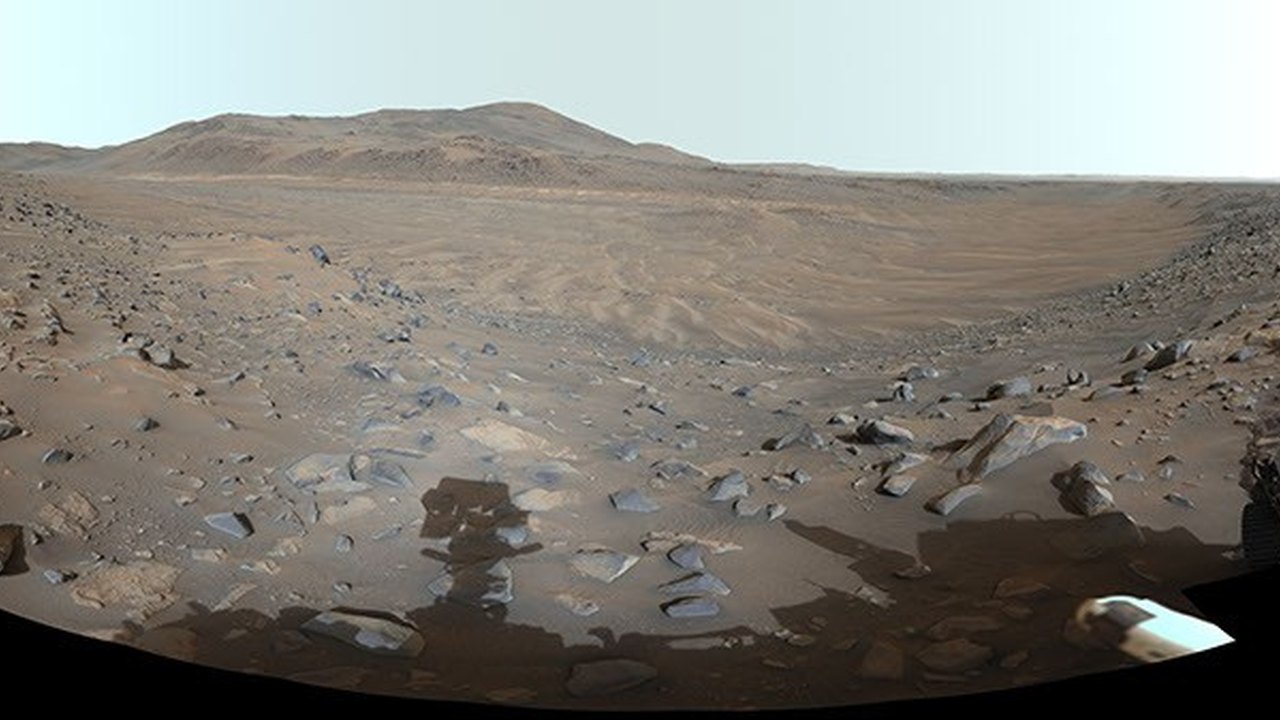
Image: science.nasa.gov — Creative Commons
A Panorama of Neretva Vallis
NASA’s Perseverance rover has captured a comprehensive 360-degree vista of Neretva Vallis, an ancient river valley located within Mars' Jezero Crater. The panoramic image provides a detailed look at the wind-swept, dusty terrain that once served as an active waterway billions of years ago.
The composite image was meticulously stitched together using 217 individual frames captured by the rover’s Mastcam-Z instrument. According to mission documentation, the data was acquired on May 20, 2024, which marked the 1,155th Martian day, or sol, of the Perseverance mission.
Geological Significance and History
While the landscape appears dry and dusty today, scientists have established that Neretva Vallis played a crucial role in the geologic history of Jezero Crater. Billions of years ago, the valley functioned as a river channel that transported and fed fresh water into the crater basin.
The released visual is an enhanced-color version. Mission specialists processed the image's color bands specifically to improve visual contrast and accentuate subtle color differences across the Martian surface strata, aiding researchers in analyzing the mineral composition and morphology of the region.
Mission Operations and Collaboration
Operations for the Mastcam-Z instrument are led by Arizona State University. The institution collaborates closely with Malin Space Science Systems in San Diego, which assisted in the design, fabrication, testing, and operation of the camera system. Additionally, the Niels Bohr Institute at the University of Copenhagen participated in the design, fabrication, and testing of the instrument's calibration targets.
The Perseverance rover itself was built and is managed for NASA by the Jet Propulsion Laboratory (JPL) in Southern California, a division of Caltech.
Practical Implications and Verification
For space enthusiasts, educators, and researchers following planetary science, this panoramic release offers valuable context regarding Martian paleohydrology—the study of ancient water systems on Mars.
What is Confirmed:
- The 360-degree panorama consists of 217 images taken by the Mastcam-Z instrument.
- The observations were recorded on Sol 1155 (May 20, 2024).
- The location imaged is Neretva Vallis within Jezero Crater.
- The processed image uses enhanced color to improve visual contrast.
What Remains Unknown:
- Specific details regarding the exact duration or volume of water flow through the channel beyond broad geological estimates.
- Fine-scale mineralogical breakdowns of every individual rock feature visible in the enhanced panorama without further laboratory or spectrometer analysis.
How to Verify:
Readers can independently examine the original image, review mission technical logs, and read further details directly through the official NASA Photojournal release at [NASA's Perseverance Views Dust at Neretva Vallis](https://science.nasa.gov/photojournal/nasas-perseverance-views-dust-at-neretva-vallis/).
AI-assisted reporting; source claims are attributed and have not been independently verified.
More to read
 AIIMS Delhi Expert Predicts Significant Gains in Childhood Cancer Survival Data Over Next Five Years
 NASA's Hubble Space Telescope Lays Groundwork for Future Roman Space Observations
 NASA Releases Preliminary Artemis II Lunar Science Report Highlighting Crew Observations and Deep-Space Data
 How Robotic-Assisted Surgery Aims to Improve Safety in Living-Donor Kidney Transplants
Trending on GlobeWire Daily
Selected from recent coverage and related topics; not live search rankings.
 Tamil Nadu Cabinet Meeting Set for October 29 Under Chief Minister Thalapathy Vijay to Review Investments and Welfare Schemes
 Amazon and Tata Motors Partner to Deploy 3,000 Electric Trucks in India Across Key Freight Corridors
 Innow8 Lists Stem Innovation Engineer Role Across Multiple Locations in Northern India
 Wordsmith Learning Hub Recruits Senior Digital Marketing Manager for Tamil Edtech Sector
 Open‑Source Windows App Turns Video into Editable Human Animation with Local AI Processing
 US Startup's Night-Time Space Mirror Demonstration Sparks Criticism from Scientists and Environmentalists