NASA-Backed Research Introduces 'Urban Pulse' Method to Track City Growth from Space
· GlobeWire Daily Editorial Desk · Source: science.nasa.gov
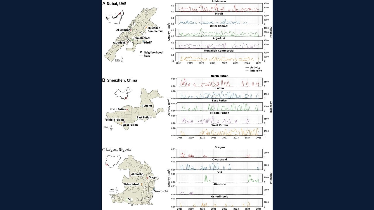
Image: NASA Science · Photo source · Resized and letterboxed to 16:9; no AI generation
A recent study published in PNAS by researchers including Zhe Zhu and Karen Seto outlines an "Urban Pulse" framework to track urban change over time using satellite data. Rather than relying on static before-and-after snapshots, the method uses Harmonized Landsat and Sentinel-2 (HLS) data combined with deep learning to measure construction activity across neighborhoods.
Tracking the Rhythm of Urbanization
The research team applied the Classify Areas with Potential and then Exclude the Stable pixels (CAPES) method to study six cities: Dubai, Lagos, Mexico City, Mumbai, Seattle, and Shenzhen. By analyzing high-frequency observations captured every two to three days, the researchers tracked fine-grained physical changes such as construction, infrastructure improvements, repairs, and demolition.
Key findings from the study include:
- Episodic Growth: Urbanization unfolds in cycles of expansion, stabilization, and decline rather than continuous linear progression.
- Asynchronous Neighborhoods: Different parts of the same city change independently, with construction spikes occurring at different times across neighborhoods.
- System Shocks: The data reflected broader disruptions, showing a synchronized dip in construction activity around the COVID-19 pandemic followed by varied local recovery rates.
Practical Implications for City Planners
Researchers suggest that monitoring neighborhood-level pulses could eventually help planners detect early signs of infrastructure strain, economic stagnation, or environmental vulnerability. Because citywide averages can mask local disparities, high-temporal-resolution data could assist officials in identifying areas that require closer investigation or targeted infrastructure upgrades.
Readers can verify these findings by reviewing the published study by Zhu et al. (2026) in *Proceedings of the National Academy of Sciences* (PNAS) or exploring ongoing Earth observation initiatives through the NASA/USGS Landsat program and the Harmonized Landsat and Sentinel-2 project.
AI-assisted reporting; source claims are attributed and have not been independently verified.
More to read
 Urban Growth Conclave: Madhya Pradesh Leaders Discuss City Development and Future Planning
 NASA Explores Super Intelligence to Enhance Science Data and Research
 SpaceX Shifts Focus Away From Traditional NASA Contracts Toward AI and Starship, Raising Questions for US Space Policy
 NASA Tests Powerful Lithium-Fed Thruster Prototype for Potential Deep Space Missions
Trending on GlobeWire Daily
Selected from recent coverage and related topics; not live search rankings.
 Madhya Pradesh Government Plans Revenue Generation from 117-Year-Old Edward Villa in Mumbai Through Leasing
 iPhone 18 Pro Named TechRadar Product of the Year 2026
 Google Project Suncatcher Runs Gemma 4 AI on Orbiting Satellite and Receives First Response
 Gender Disparities in Eye Care Access Across India Examined
 Satellite Images Show Cyclone Arnab Weakening Over India As New System Brews
 Expanding Green and Blue Spaces Crucial for India's Economic and Public Health, Reports Indicate